
A group of researchers from ICARUS, supported by climate scientists at Met Éireann, have carried out a rapid attribution study on the two-day rainfall levels recorded in Dublin, Wexford, and Wicklow on the 14 and 15 November 2025 during Storm Claudia. The study also examines the 30-day antecedent rainfall conditions across Dublin, Carlow, Kildare, Kilkenny, Laois, Louth, Meath, Wexford, and Wicklow.
This period of heavy rainfall followed several months of unusually wet conditions. September recorded 144% of its average rainfall and October recorded 123%. Widespread rain continued well into November, with localised extremes. Johnstown Castle weather station in Co Wexford recorded 58% of its long-term average November rainfall in a single 24-hour period on 14 November (measured against the 1991-2020 long term average).
These conditions left soils saturated, river levels elevated, and catchments highly responsive to additional rainfall.
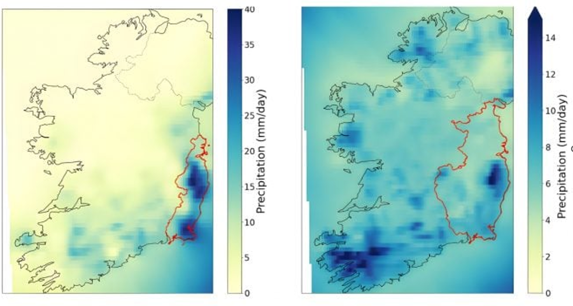
The study uses two event definitions to understand the factors that contributed to flooding in the south-east. The first looks at the two-day rainfall event affecting Dublin, Wexford, and Wicklow, which were under an orange warning. The analysis covers Ireland’s wettest months of October, November, December, and January.
The second looks at 30-day yearly maximum rainfall across nine counties whose rivers feed into the south-eastern catchments under the orange warning. This combined approach highlights both the intense short-term rainfall and the prolonged wet conditions that contributed to the flooding risk.
Main findings
· Analysis of hydrometric data shows that the two-day rainfall associated with Storm Claudia caused significant but not exceptional flooding, with several rivers in Wexford and Wicklow recording their highest or second-highest peaks, although on short records; longer-term records show the event had a return period of roughly 20–30 years, indicating it was moderately rare rather than extreme.
· In comparison to a pre-industrial climate, the magnitude of the rainfall associated with the two-day event in Dublin, Wexford and Wicklow has increased by nearly 12%.
· With further global warming, we expect similar two-day rainfall events to have a further 1%, 3%, and 8% increase in magnitude from today for climates 1.5°C, 2.0°C, and 3.0°C warmer than pre-industrial levels respectively.
· In comparison to a pre-industrial climate, the magnitude of the rainfall associated with the 30-day event in Dublin, Carlow, Kildare, Kilkenny, Laois, Louth, Meath, Wexford, and Wicklow has increased by nearly 7%.
· With further global warming we expect similar 30-day rainfall events to have a further 0.5%, 2%, and 4.5% increase in magnitude from today for climates 1.5°C, 2.0°C, and 3.0°C warmer than pre-industrial levels respectively.
· Both the two-day and 30-day rainfall events have already become twice as likely as would have been the case in a pre-industrial climate. On a warmer planet, with 3.0°C of global warming, we would expect similar two-day rainfall events to happen once every 1-2 years and 30-day rainfall events to happen once every 2 years.
This rapid climate attribution study was carried out by researchers at Maynooth University, supported by Met Éireann climate scientists, under the umbrella of the WASITUS project. WASITUS aims to build an operational event attribution capability for Ireland in collaboration with the World Weather Attribution (WWA) team.
